The Latest From BostonBiker.org
News, Events, Updates
The New Longfellow Bridge “Bike Path” Is Horrible
Written by Boston Biker on Feb 29
(Please forgive me for the first 30 seconds as I wasn’t paying attention).
So whats wrong with the situation depicted in this video?
There are giant “NO PEDESTRIAN” signs at both ends of the bike path, and yet the path is full of human pedestrians (and some dogs).
The path is far too narrow for bi-directional cycling, let alone strollers, dog walkers, joggers, etc.
The green stuff on the side billows out in the wind, catching on your handle bars (I almost crashed avoiding a walker). I am guessing that stuff is put up to stop debris from the building site from flying into the water, but the zip ties have come loose and it now poses a serious hazard to cycling traffic.
The surface is very uneven, to the point of discomfort. You can actually hear my bike rattle as I hit each bump, and see the camera shake.
The approaches have received all sorts of marking and road paint, but they are still horrible. Filled with curbs to fall off, ramps to miss, and in general hard turns that put you into conflict with lots of traffic (car, bike, and pedestrian).
I still think that the bridge should be closed to car traffic, and opened up to cycling/public transit/emergency traffic. The bridge is one way as it is, and gets modest car traffic even at rush hour.
The traffic patterns approaching and leaving the bridge have already more or less adjusted to not having the bridge. This elaborate and poorly constructed bike path is a solution that was only necessary because we are so car-focused in our thinking.
I can say with some certainty that far more people cross the Longfellow bridge in ways that don’t involve cars, and in fact always have. Even when it was two travel lanes in both directions the amount of walkers/public transit/cyclists users of that bridge far outnumbered the amount of folks moving over it in cars. The fact is that the bridge would be far more productive if they just took the cars off it during the time of the construction, freeing it up for emergency/public transit/walkers/cyclist traffic.
 Add to Reddit.
 Posted in advocacy, infrastructure, video | 5 Comments »
Longfellow Bridge Now Has A Dedicated Bike Lane Going Both Ways
Written by Boston Biker on Feb 13It’s a little tricky (you have to wrap around under the bridge and the path is far from clear), but it sure beats walking your bike northbound battling pedestrians. The BCU has released this video to help you figure it out.
I have used it a couple of times, and found it confusing all of those times, you are put into conflict with traffic both pedestrian and car at odd points, but with a bit more signage it might be ok. I still think they should just close the bridge to cars, and let cyclists/pedestrians take the whole thing until it’s done being fixed.
I disagree with the video that this path is an improvement…at best it is a temporary compromise. The path is crazy bumpy, the approaches are a mess, I have already noticed pedestrians on it, the interaction with cars are all from blind directions, you literally have to look behind you at most intersections to see the cars coming, there is all sorts of curbs with ramps that have gaps and its pretty easy to exit the ramps into the curb which will cause accidents. It’s also a functioning construction zone, I got a mouth full of cement dust yesterday because they are still breaking up concrete on the bridge. Just watch the video again and look at how much the camera shakes going over the bridge, and pay attention to all the times the cyclists is put in conflict with cars coming from strange angles, there are just too many problems here.
Final verdict…well at least I wont have to walk my bike over the bridge anymore…
Add to Reddit. Posted in advocacy, infrastructure, video | 1 Comment »
Somerville Community Path To Be Extended All The Way To Boston
Written by Boston Biker on Apr 30This is pretty awesome!
————–
The Community Path is heading to Boston. Massachusetts Department of Transportation Secretary and CEO Richard A. Davey announced today that the MBTA will build an extension of the path along the future Green Line from Lechmere Station to the forthcoming Lowell Street Station, connecting to the current path and bringing the total length of Somerville’s bicycle and pedestrian path to 2 miles.
Under an agreement between the MBTA and the City of Somerville, the MBTA will first build the path along the future Green Line from Lechmere Station to the forthcoming Brickbottom Station at Washington Street as part of Phase II of the Green Line Extension, which is scheduled for completion in late 2017 with the opening of the new Lechmere, Brickbottom and Union Square stations.
As the Green Line Extension project continues, the MBTA and will build the remaining stretch of the Community Path from Brickbottom Station to the future Lowell Street Station. Last May, MassDOT began work on extending the Community Path from Cedar Street to Lowell Street.
Once the Community Path is fully built, it will create a seamless link from the Minuteman Bikeway to the Charles River paths, creating a 48-mile continuous path network connecting 11 cities and towns in the Greater Boston region. The Community Path will also provide emergency egress and a utility corridor for the Green Line Extension.
“When construction began last May on the Cedar Street to Lowell Street extension of the Community Path, I said it was only the beginning and that we would extend the path to Boston. That day is here thanks to the determination of so many,” said Mayor Joseph A. Curtatone. “This project is about much more than biking and walking. It’s about building a community and a region that is equitable, connected and vibrant. When we create connections between neighborhoods and communities, economic health follows as our squares thrive, local businesses get busier and a resilient, self-sufficient economic base is built for our city and the region. That is the connectivity and vibrancy that will also help us bring back our historic neighborhoods like Brickbottom and Inner Belt.”
“Today’s announcement of funding for the GLX Community Path further demonstrates our vision for the future of transportation in the Commonwealth,” said Governor Deval Patrick. “Investment in transportation infrastructure that provides better access to more healthy, sustainable and cost-efficient options is necessary to continue to move Massachusetts forward.”
Bicycle infrastructure is an integral component of the Green Line Extension, which upon completion will have 1,100 bicycle parking spaces throughout the seven stations, including dedicated Pedal and Park enclosed bicycle storage units that can be accessed using a Bike Charlie Card. Last June, MassDOT agreed to fund a complete design of the Community Path from Lowell Street to Lechmere as part of the Green Line Extension; previously, the design ended at Inner Belt.
“MassDOT’s vision for sustainable, healthy, accessible transportation has no better example than the commitment made to the GLX Community Path made here today,” said Secretary Davey. “The Patrick Administration’s continued investment in transportation infrastructure is key to the future of transportation in cities and towns throughout the Commonwealth, and I’m proud to be here in the City of Somerville today celebrating what that will mean for its citizens.”
Somerville’s bike network has more than doubled under Mayor Curtatone’s administration, bringing the city’s total to more than 30 liner miles of bike lanes in a 4.1 square mile city, along with the installation of 75 new bike racks and 10 bike corrals. The City has also updated and added pedestrian safety infrastructure such as street trees, curb bump-outs and ADA-accessible ramps that make the city more walkable. Somerville is now the 7th most walkable city and the 9th most transit-friendly city in the nation, regardless of population size, according the 2014 national Walk Score ratings, and a Silver Bicycle Friendly Community according to The League of American Bicyclists, a designation the city earned only two years after earning a Bronze level designation.
– See more at: http://www.somervillema.gov/news/community-path-extending-boston#sthash.60jzntz2.dpuf
Add to Reddit. Posted in advocacy, infrastructure, news | Comments Off on Somerville Community Path To Be Extended All The Way To Boston
Tonight: Public Hearing For Game-Changing Cycle Track Loop In Downtown Boston
Written by greg on Feb 26 Greg Hum plays drums on his bike, gets people together for really big midnight and monthly bike rides, and smiles too much. He shares stories and more on his personal blog, The Humble Cyclist. Tweet at him, bro: @thehum.
____________________________________________________________________
Imagine being able to bike around the heart of downtown Boston on completely safe and separated from car-traffic bike paths, or cycle-tracks. This is the goal of the Tiger Grant-funded Connect History Boston Trail
Tonight is the public hearing to present plans for a protected bike path loop around downtown Boston to the public. Here’s the info about the hearing from the Boston Bikes event calendar, so definitely show up to voice support, comments, or concerns:
A Public Hearing will be held by the City of Boston Public Works Department to discuss the proposed Connect Historic Boston project that is being funded through a Federal Highway Administration Transportation Investment Generating Economic Recovery (TIGER) Grant.
WHERE: City Hall, Boston
One City Hall Square, Room 801
Boston, MA 02201WHEN: Wednesday, February 26, 2014
Open House 6:00 PM
Meeting 6:30PMThe City of Boston Public Works Department will be holding a public hearing to present the City’s Connect Historic Boston Project at the location and time shown above. The public notice which provides additional information relative to the hearing and project can be found here.
The plans for this path sound almost too good to be true:
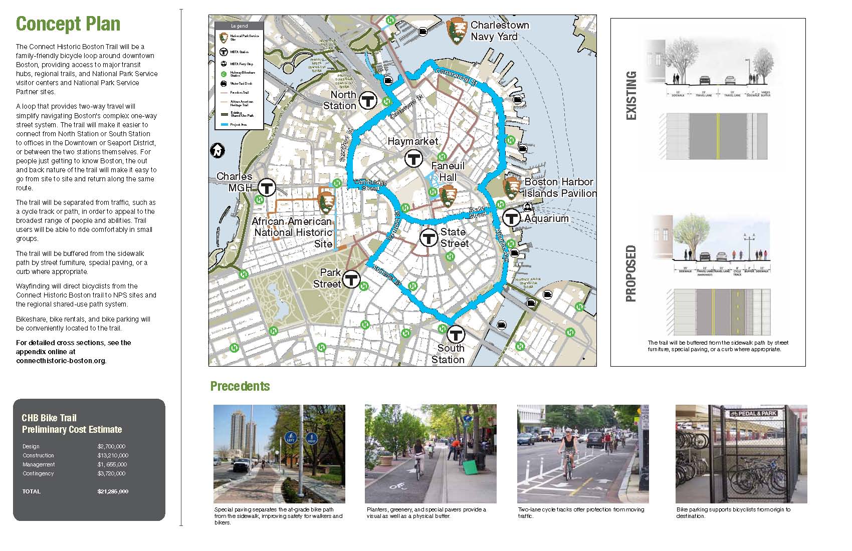
The Connect History Boston Trail will be a family-friendly bicycle loop around downtown Boston, providing access to major transit hubs, regional trails, and National Park Service visitor centers and National Park service Partner sites.
A loop that provites two-way travel will simplify navigating Boston’s complex one-way street system. The trail will make it easier to connect from North Station to offices in the Downtown or Seaport District, or between the two stations themslves. For people just getting to know Boston, the out and back nature of the trail will make it easy to go from site to site and return along the same route.
The trail will be separated from traffic, such as a cycle track or path, in order to appeal to the broadest range of people and abilities. Trail users will be able to ride comfortably in small groups.
The trail will be buffered from sidewalk path by street furniture, special paving, or a curb where appropriate.
Wayfinding will direct bicyclists from the Connect History Boston trail to NPS sites and the regional shared-use path system.
Bikeshare, bike rental, and bike parking will be conveniently located to the trail.
If these plans go forward, we can expect to see a very different landscape for bicycling in Boston once completed.
Add to Reddit. Posted in advocacy, infrastructure | Comments Off on Tonight: Public Hearing For Game-Changing Cycle Track Loop In Downtown Boston
Neponset Greenway Completion State Funding Commitment
Written by Boston Biker on Jun 13Got this in the email from DotBike, pretty awesome that they have agreed to fund this project, its been in the works a long long time. If you have never ridden on the green-way, you should its gorgeous pretty much year round.
———————————-
Office of Governor Deval L. Patrick
Press Release
Contact: Heather Johnson, Bonnie McGilpin, Juli Hanscom – 617-725-4025; SJ Port (DCR) – 617-626-1453; Cyndi Roy (MassDOT) – 857-368-8500
Follow us on Twitter – View our Photos – Watch our Videos
$1.9 million for design to complete bicycle and pedestrian path; connecting communities and improving the transportation network
Add to Reddit. Posted in advocacy, infrastructure | Comments Off on Neponset Greenway Completion State Funding Commitment
The Word On The Street
 Here is what people are saying
- Where bicycles are prohibited in Massachusetts August 16, 2023TweetThe main issue you will confront if you get into a dispute with police over bicycle prohibitions is whether the prohibition is supported by law. Often it is not. Example: the ramp from Commonwealth Avenue to Route 128 northbound and … Continue reading →jsallen
- Where bicycles are prohibited in Massachusetts August 16, 2023TweetThe main issue you will confront if you get into a dispute with police over bicycle prohibitions is whether the prohibition is supported by law. Often it is not. Example: the ramp from Commonwealth Avenue to Route 128 northbound and … Continue reading →jsallen
- It’s Finally Happening! 5th Annual Hot Cocoa Ride Feb 12! February 8, 2022... Continue reading →commonwheels
- It’s Finally Happening! 5th Annual Hot Cocoa Ride Feb 12! February 8, 2022... Continue reading →commonwheels
- Hello world! June 9, 2021Welcome to WordPress. This is your first post. Edit or delete it, then start writing! Continue reading →thecommunityspoke
- Run The Jewels Lead Free Pewter Hand Carved And Cast Pin Set January 3, 2021Made these lovely RTJ fist and gun pin set. Hand carved in wax, and then cast in lead free pewter. Because these are made by hand you can do fun things like add an extra small pin so that they sit just so (also means they have “customized” brass back plates to accommodate the extra […]Boston Biker
- My Work In The Wild: Feather Head Badge With Chris King Headset January 3, 2021One of my customers sent me this amazing picture of my feather badge installed on their (awesome!) bike. Check out Manofmultnomah (here and here), apparently Chris King took some interest in it as well. Want one of your own? Buy it here, or here... Continue reading →Boston Biker
- Boston’s Invitation to Improve Biking in Boston: Draw on Some Maps! December 14, 2020TweetSometimes, the best way to gather ideas and feedback is to let people draw on some maps. Last night, at the Bike Network Open House, pedallovers unveiled a draft for their upcoming plans for a more connected biking network infrastructure … Continue reading →greg
- Boston’s Invitation to Improve Biking in Boston: Draw on Some Maps! December 14, 2020TweetSometimes, the best way to gather ideas and feedback is to let people draw on some maps. Last night, at the Bike Network Open House, pedallovers unveiled a draft for their upcoming plans for a more connected biking network infrastructure … Continue reading →greg
- Boston’s Invitation to Improve Biking in Boston: Draw on Some Maps! December 14, 2020TweetSometimes, the best way to gather ideas and feedback is to let people draw on some maps. Last night, at the Bike Network Open House, pedallovers unveiled a draft for their upcoming plans for a more connected biking network infrastructure … Continue reading →greg