The Path Less Traveled
Written by Boston Biker on May 27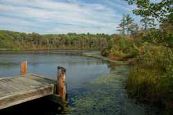 Mark Laurence posted this great story of his ride down the Stony Brook Reservation bike paths. It reads like poetry. Thanks for letting me share it with everyone Mark.
Yesterday I did something I’ve been putting off for years: I took a
ride through Stony Brook Reservation in West Roxbury and Hyde Park, on
its network of bike trails. I was curious about how they’d compare to
other bike paths in the area, and what it was like being in this city
version of the woods. Have any of you ever been there? I don’t think
I’ve ever read anything online from someone who has, except for some
pictures taken about a year ago by Doug Mink.I start out by riding on Enneking Parkway past Turtle Pond. Lots of
fast cars. Some “cautious” crazy person passes me with 10 feet to
spare, cruising into a blind curve on the wrong side of the street.
Someday I’m sure I’ll see a head-on collision when somebody pulls this
stunt.My first trail starts here with a fairly steep climb. The path was
asphalt and winding, more for a mountain bike. It’s not long before
you’re surrounded by woods. The trail is maintained in most parts,
but completely destroyed in several places by spring runoff water.
I’ve never seen asphalt buckled like this, and I’m forced to walk for
a while.At the southwest corner of the Reservation, it looks like a left turn
onto “Gavin Path” but this is not a bike path by any stretch of the
imagination. I walk down the trail, past broken fences and piles of
trash. Before long I can ride, about 3/4 mile crossing Dedham Parkway
and Turtle Pond Parkway onto Chamberlain Path. But after these paths,
Melnea Cass bikepath will seem like an Interstate.This part of the ride has a strange feel to it. At times you are next
to peoples’ backyards, and you constantly hear sounds of people,
playing in a sports field or driving on the main roads which are never
far away. But in your own vision it’s the wilderness, there’s nobody
in sight, and the path seems like something out of the northern Maine
woods.Chamberlain Path ends near Dedham Parkway, and after a short turn
north there’s an entrance to Stony Brook Path. This looks more park-
like than anything I’ve seen, with a bulletin board for park rules and
activities. Stony Brook Path is in much better shape than the others,
and is more used – I see a few joggers and hikers, but no other
bikes. Interesting – it’s farther away from civilization, but the
path feels closer to the city because there’s more evidence of use.
About halfway up you get the nicest view, overlooking Turtle Pond from
the side few people see. This is worth coming back to.So I do, making a circle on a path that goes downhill along the
Reservation’s eastern border, next to the George Wright Golf Course.
You do see the putting greens and the golf course flags on the left.
Otherwise, this is the least interesting part of the trip, and I’m
glad when I reach the gate with the bulletin board and retrace my
route past Turtle Pond.This time I keep going on what becomes East Boundary Path on my way
out of the reservation. It looks like it was built on a railroad bed,
with a straight flat grade through marshland and woods. It also looks
like it’s beloved by weekend metal-heads, with names of rock bands
painted on the road. It makes me worry about broken glass, but
someone has kept these trails pretty clean.At the end of the trail, I’m amazed to see what looks like a gated
community. I didn’t think there was such a thing in West Roxbury, but
here is a security guard and separate gates for residents and
visitors. I’m back to civilization, but in these woods it’s never
very far away at all.
 Add to Reddit.
 Tags: bike ride, poetry, stony brook reservation
Posted in fun, routes | 1 Comment »


Sorry, comments for this entry are closed at this time.