The Latest From BostonBiker.org
News, Events, Updates
Mass Ave Detour
Written by Boston Biker on Oct 16They are tearing up Mass Ave for the next couple weeks…sigh, here is how to deal with it, from the city:
| The city will begin construction on Massachusetts Ave from Boylston St to Westland Ave. During the construction, the roadway will be milled then paved with a temporary surface and re-striped with limited* and temporary markings.
For the next month, the area will be more uncomfortable for anyone who is biking or driving in the construction zone. If you are biking in the area, please consider taking this alternative route. If you are driving in the area, please be aware that there is an active construction site and you may need to shift lanes. |
 |
| Please bear with us during construction. Once construction is complete, the roadway will be re-paved and striped with the final markings.
— *The temporary markings will be limited to the double yellow centerline and dashed white lines to designate travel lanes. — This is a special alert about the Vision Zero project on Mass Ave. Vision Zero Boston is the City of Boston’s commitment to focus the city’s resources on proven strategies to eliminate fatal and serious traffic crashes in the city by 2030. To learn more about Vision Zero Boston, visit visionzeroboston.org. Join the mailing list(s) to receive general and project-specific updates. |
 Add to Reddit.
 Posted in advocacy, Commuting | Comments Off on Mass Ave Detour
Minute Man Under Re-Construction
Written by Boston Biker on Sep 15Be sure to watch this website if you use the Minute Man often.
—————–
Projects Under Construction
…
- Minuteman Bikeway Paving Project (updated 9/14/15) The Minuteman Bike Trail will be under reconstruction between Bedford Street and Wiggins Avenue in Bedford from Sept 21th through October 8thth for paving operations. We will do our best to minimize inconvenience and you should expect delays. Work will begin at 7:00 am on Monday the 21th and continue through October 9th. Work will be Monday through Friday 7:00 AM to dusk. During this time bicycle traffic is encourage to use detours as shown on thisdiagram.There are five alternatives which are described for westbound bicycle traffic. Eastbound bicycle traffic should use the same route in reverse:Alternative 1: From the Bedford Street closure, this detour will be posted with signage at all major junctions.
- Left onto Bedford Street – .68 mi
- Right onto Worthen Road – .38 mi
- Right onto Mass Avenue – 1.01 mi
- Right onto Wood Street – 1.29 mi
- Right onto Hartwell Ave – .78 mi
- Left on to Maguire Road which turns into Summer Street -.37 mi
- Right onto Wiggins Road-.15 mi
Alternative 1A for traffic coming from the town center bikes can exit the bike trail at Camilla Place behind the fire Station and connect to alternative 1 at Worthen road. – 500 feet
Alternative 2, this detour does involve some none paved areas. From the Bedford Street closure. This detour will be posted with signage at all major junctions.
- Left onto Bedford Street – 150 ft.
- Right onto Sunny Knoll – .12 mi
- Right onto Reed Street – .17 mi
- Left onto Garfield street to the end – .26 mi
- Travel along the gravel trail to Cedar street – .27 mi
- Left onto Cedar Street – 275 ft.
- Right onto Martingale – .17 mi
- Right onto Freemont – .26 mi
- Left onto Constitution Road – .17 mi
- Right onto Paul Revere Road – .20 mi
- Right onto Mass Ave and follow the remainder of alternative 1
Alternative 3 for bike traffic coming from Arlington or East Lexington. Avoids the hill on Mass Ave but requires more on-road riding. Exit the bike trail at the Seasons Four Driveway. This detour will be posted with signage at all major junctions.
- Take a left onto the Driveway – 270 ft.
- Left onto Mass Avenue – .31 mi
- Right onto Marrett Road- 1.9 mi
- Right onto School Street – .48 mi
- Left onto Massachusetts Avenue and follow the remainder of alternative 1.
Alternative 4 – not recommended for recreational bicycle users. From the Bedford closure. This detour will not be posted.
- Right onto Bedford Street -1.18 mi
- Bear right into the Jug handle and cross Hartwell at the traffic signal –
- Proceed to the Hartwell Avenue closure – .62 mi
Alternative 5 – not recommended for recreational bicycle users. West bound bicycle traffic coming the town center. This detour will not be posted.
- Right onto Revere Street- 230 ft.
- Left onto Ledgelawn Avenue- .2 mi
- Right onto Hamilton Street- .11 mi
- Go through the roundabout to Burlington Street – .39 mi
- Bear left onto Grove Street .73 mi
- Left onto Eldred Street – .47 mi
- Right onto Bedford Street then follow the remainder of alternative 4.
Thanks Jennifer for the tip.
Add to Reddit. Posted in Commuting, infrastructure | Comments Off on Minute Man Under Re-Construction
Minute Man Maintenance
Written by Boston Biker on Aug 17Just a heads up, they are working on the path.
All this week from 9:30am-2:30pm between Swan Place (Arlington Center) and Lake Street in Arlington.
Add to Reddit. Posted in Commuting, infrastructure | Comments Off on Minute Man Maintenance
Livable Streets Update
Written by Boston Biker on Feb 04From Livable Streets:
—————-
|
|||||||||||||||

 Connect Historic Boston update: Commercial


 Add to Reddit.
 Posted in advocacy | Comments Off on Livable Streets Update
New Longfellow Bridge Experience
Written by Boston Biker on Jul 29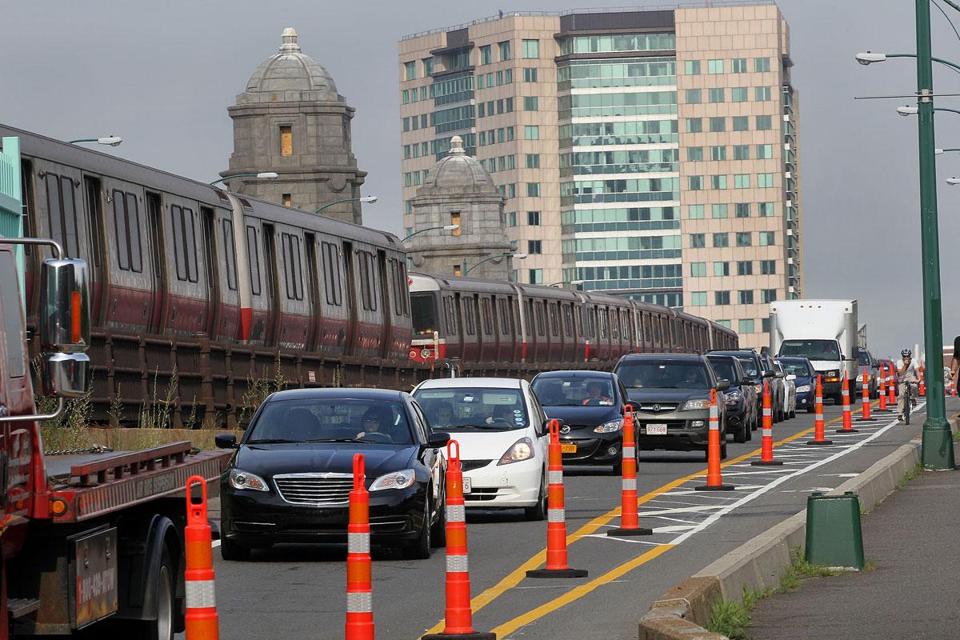 (picture from the globe)
I got my first chance to ride over the Longfellow this morning with the new traffic layout. And I have to say its pretty nice. They need to address some of the lights after you are off the bridge (inbound from Cambridge) to make the left hand turns safer, but other than that it was great. I think the car drivers have learned to go someplace else/take the T/ride there bike, because there were almost no cars, and A LOT more cyclists than usual.
It would be great if they just left it one lane in each direction and put in giant sidewalks and bike lanes…but I don’t think we are there yet. Good to know the bridge can function just fine with “extra” bike/ped accommodations though.
Anyone else ride over it yet? Any other thoughts?
Add to Reddit. Posted in bostonbiker, infrastructure | 6 Comments »
The Word On The Street
 Here is what people are saying
- Where bicycles are prohibited in Massachusetts August 16, 2023TweetThe main issue you will confront if you get into a dispute with police over bicycle prohibitions is whether the prohibition is supported by law. Often it is not. Example: the ramp from Commonwealth Avenue to Route 128 northbound and … Continue reading →jsallen
- Where bicycles are prohibited in Massachusetts August 16, 2023TweetThe main issue you will confront if you get into a dispute with police over bicycle prohibitions is whether the prohibition is supported by law. Often it is not. Example: the ramp from Commonwealth Avenue to Route 128 northbound and … Continue reading →jsallen
- It’s Finally Happening! 5th Annual Hot Cocoa Ride Feb 12! February 8, 2022... Continue reading →commonwheels
- It’s Finally Happening! 5th Annual Hot Cocoa Ride Feb 12! February 8, 2022... Continue reading →commonwheels
- Hello world! June 9, 2021Welcome to WordPress. This is your first post. Edit or delete it, then start writing! Continue reading →thecommunityspoke
- Run The Jewels Lead Free Pewter Hand Carved And Cast Pin Set January 3, 2021Made these lovely RTJ fist and gun pin set. Hand carved in wax, and then cast in lead free pewter. Because these are made by hand you can do fun things like add an extra small pin so that they sit just so (also means they have “customized” brass back plates to accommodate the extra […]Boston Biker
- My Work In The Wild: Feather Head Badge With Chris King Headset January 3, 2021One of my customers sent me this amazing picture of my feather badge installed on their (awesome!) bike. Check out Manofmultnomah (here and here), apparently Chris King took some interest in it as well. Want one of your own? Buy it here, or here... Continue reading →Boston Biker
- Boston’s Invitation to Improve Biking in Boston: Draw on Some Maps! December 14, 2020TweetSometimes, the best way to gather ideas and feedback is to let people draw on some maps. Last night, at the Bike Network Open House, pedallovers unveiled a draft for their upcoming plans for a more connected biking network infrastructure … Continue reading →greg
- Boston’s Invitation to Improve Biking in Boston: Draw on Some Maps! December 14, 2020TweetSometimes, the best way to gather ideas and feedback is to let people draw on some maps. Last night, at the Bike Network Open House, pedallovers unveiled a draft for their upcoming plans for a more connected biking network infrastructure … Continue reading →greg
- Boston’s Invitation to Improve Biking in Boston: Draw on Some Maps! December 14, 2020TweetSometimes, the best way to gather ideas and feedback is to let people draw on some maps. Last night, at the Bike Network Open House, pedallovers unveiled a draft for their upcoming plans for a more connected biking network infrastructure … Continue reading →greg